Application GIS technology on Municipal Office in Bělkovice-Lašťany
Introduction
This page describes the work on Municipal office in Bělkovice - Lašťany with the tool of GIS technology for support decisions and obtain information about the municipal area. The first steps and contacts with GIS technology we have done on 1996. The firm Geometra Opava created the digital cadastral map for the Municipal office. They used free SW ArcView 1.0. The layers where transformed into ESRI coverage format and after agreement with District office in Olomouc, in which is included to, obtained the clip of four map pages M 1 :10000 with basic topographic information from digital database of District office. On the end of 1998 the referents decided to use from the firm T-MAPY Hradec Králové product T-MapViewer 2.0 - viewer of geographic data included module Filing of properties. On the beginning of the year 2004 they use a new product GISel PRO with module SIRISKN. This viewer is a modular product, you can add more modules into it. Localize, Coordinates systems, Hotlink etc...
The decision of region and self-government helper
GISel PRO offers to users basic view and query functions. It is easier alternative on work places, where ArcView is too strong and powerfull tool. You can view data in standard ESRI formats (vector and raster), coverage, Shape files.
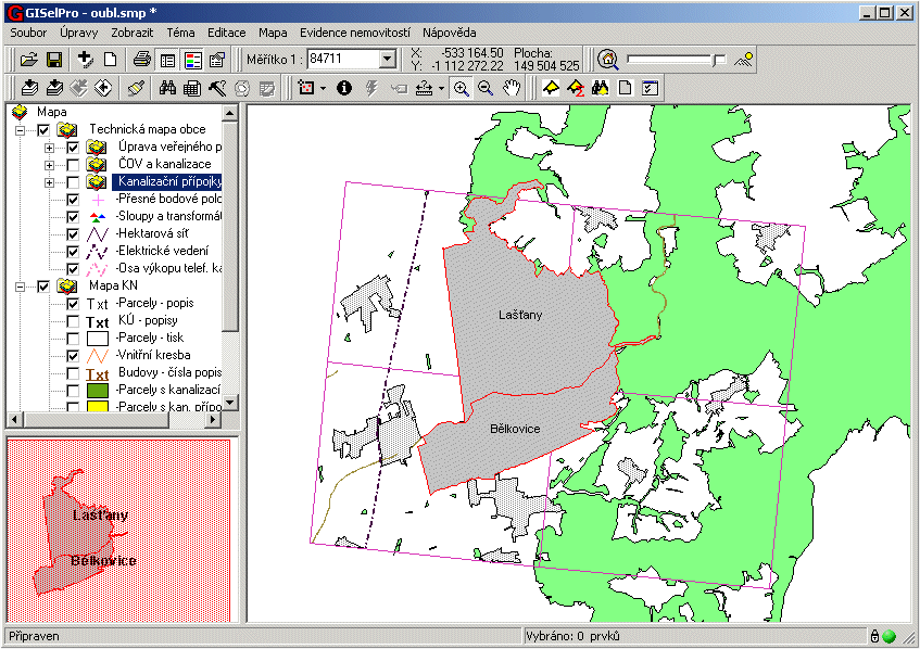
The viewer contains three windows. Inside the left up List of layers window we can see theme tree or sets of themes. Inside the bottom Overview map window viewer offers summary about the region of interest to make the orientation easier. Main window shows thematic layers switched on or off. We can add new themes into the list of layers by Layers explorer. (see pict.1. - Region of municipality)
Pict.1. - Region of municipality
Themes in Shape file format on municipality office are divided into well-arranged sets (in order how they are drawn):
Set of maps scale 1 : 10000 contains clip of four map pages from scale 1:10000 with basic topographic layers.
Set of Cadastral map contains these layers:
One of the basic database for referents of municipality office is database of description information connected into digital cadastral map. Like a complement they can use clip of the map in scale 1 : 10000, previously delivered to municipality office on 1996 included ArcView 1.0.
Other important datasets are three sets of themes the 1. phase technical map, prepared during the second half of the1998 year. There are:
Source data prepared the firm Civilní zeměměřičská kancelář s.r.o Brno. Vector layers in DGN format, attributes and located objects coordinates in text files.
Set of sewerage connections contains layers with sewerage connections and located objects - trap-door. Set of WCS and sewerage contains layers of water cleanning station and set of Adaptation of public open space contains layers with located objects inside adapted area.
All data are converted into shape files and saved inside one project.
Users at ease access to information from files of description information of each parcel or parcels. On the card Information about the parcel user finds common records of this parcel and its owner, tenant. User can showed information after print type selection print. Except these functions user can run the search menu and find respective parcel or parcels by typing the parcel number or owner name, number of owner card etc. (see pict.2. – Information from SPI)
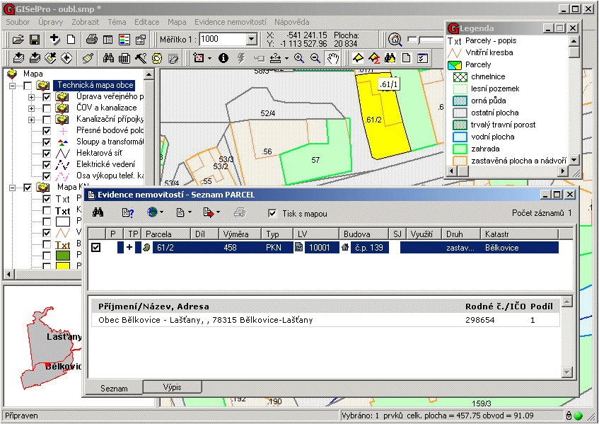
Pict.2. – Information from SPI
An example obtained information from this system I show here information about a sewerage pipeline, its attributes, where user can see data about the material, cross-section of pipeline and on located points finds height of the bottom, height of trap-door and declivity (see pict.3. – Information about sewerage).
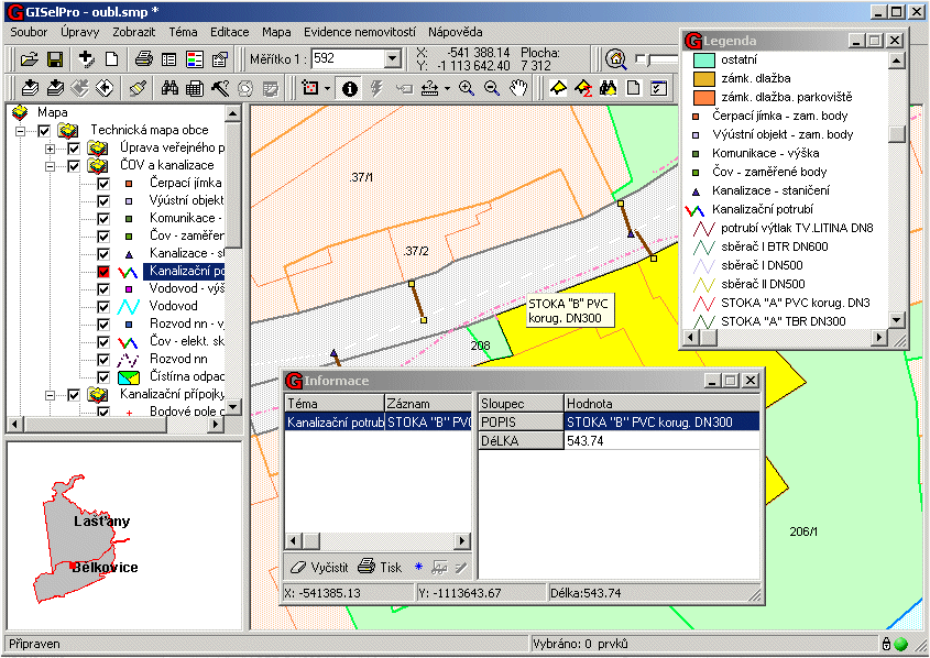
Pict.3. – Information about sewerage
Next example shows output from database about low voltage cable, which feeds water cleaning station. Its information layer is nowdays prepared (see pict.4. – Information about LV cabel).
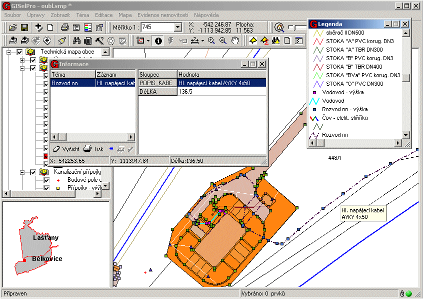
Pict.4. – Information about LV cabel
This information system is open and we can add other important themes, which are continuously prepared and so improve information capacity of municipal office database.
Conclusions
New GIS technology on Municipal Office in Bělkovice - Lašťany brings to referents expressive quality change in access to information about their area of municipality and more improved power of this municipality self-government. These first steps are the basis, on which we can build other information layers with attributes the dynamicaly changed technical map and other basis needed to decision activity in self-government and area planning.